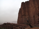
Fisher Towers
Fisher Towers Trail
When I first started exploring the southwest, long before google maps or the internet, I was traveling I70 in Utah and noticed a tiny line on my well worn atlas that appeared to be a shortcut to Arches National Park. The tiny line turned out to be an amazingly beautiful road, not well maintained back then but notably better now, that followed the Colorado River through scenes of immense beauty.
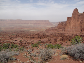
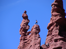
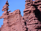
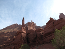
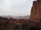
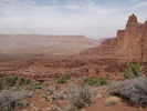
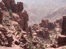
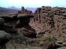
When I spotted a dirt road with a dusty sign for "Fisher Towers", I followed the rutted and rough road to a parking lot, then proceeded on foot along a trail. The Fisher Towers trail is amazing - the sights unfold as you slowly ascend to a long ridge far away. At every turn a new facet of the landscape is revealed, tiny intricacies backdropped by sweeping vistas. This is a moderately hard hike, but well worth it. I've done it three times. I'll do it again.
- Approach
-
From the junction of Interstate Hwy 191 and Utah-128 north of Moab, drive 21.0 miles northeast along Utah-128 to Fisher Tower Rd.
At Fisher Tower Rd, turn right and follow the rough dirt road 2.1 miles to the trailhead parking lot.
Coordinates for the hike: 38.7249070,-109.3087070
- Parking / Trailhead amenities
- The dirt and gravel parking lot is level and has room for several cars. There is a clean pit toilet and a map board with information about the hike. There is no water available. This hike is moderately long, difficult, and very dry - you will need to carry water with you.
- Trail observations
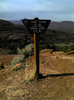
- The trailhead exits directly from the parking lot. There is a trail register that you should sign.
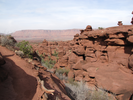
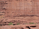
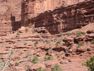
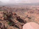
Generally the trail is in good shape and easy to follow due to a lot of footprints and grooving in the sand and dirt sections. There are cairns to follow when the trail crosses solid rock.
The trail generally ascends, though there are several places where the trail drops into canyons to cross them. With only a single exception, the trail stays away from any cliffs. The single exception is a place where you go through a notch in a rock ridge - immediately on the other side of the notch there is a sheer drop off, and the trail narrows to only a couple of feet. I was hiking with my 9 year old son, and I was pretty nervous watching him. - Trail statistics
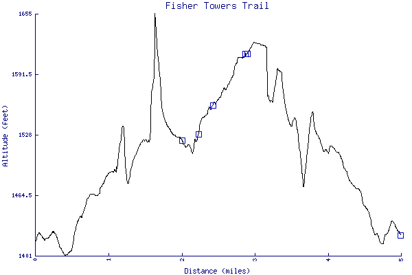
- The trail is 4.99 miles long. The sum of all the uphill climbs is 628 feet.
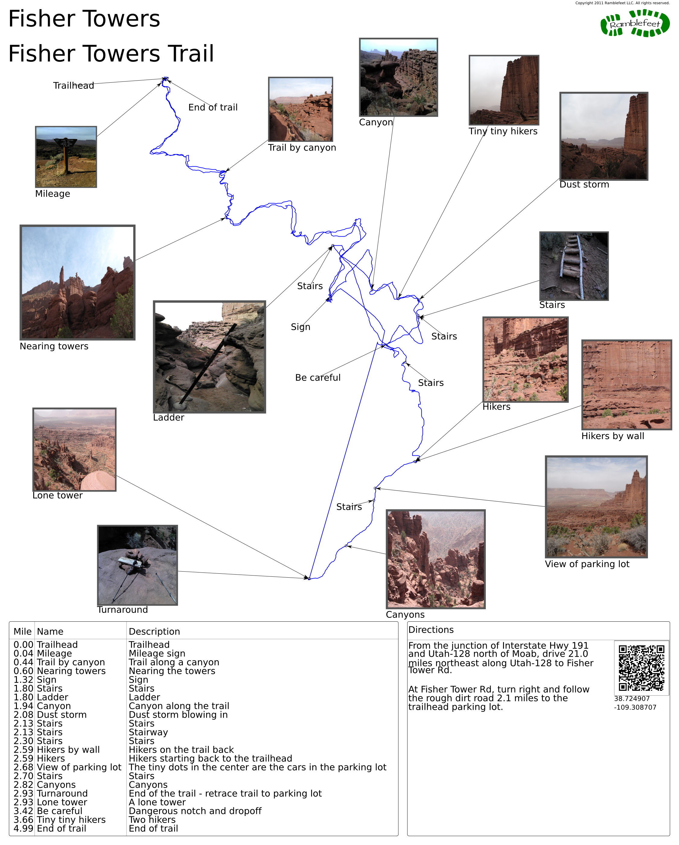
- Trail waypoints
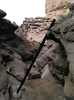
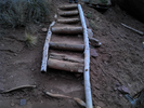
0.00 mi Trailhead Trailhead 0.04 mi Mileage Mileage sign 0.44 mi Trail by canyon Trail along a canyon 0.60 mi Nearing towers Nearing the towers 1.32 mi Sign Sign 1.80 mi Stairs Stairs 1.80 mi Ladder Ladder 1.94 mi Canyon Canyon along the trail 2.08 mi Dust storm Dust storm blowing in 2.13 mi Stairs Stairs 2.13 mi Stairs Stairway 2.30 mi Stairs Stairs 2.59 mi Hikers by wall Hikers on the trail back 2.59 mi Hikers Hikers starting back to the trailhead 2.68 mi View of parking lot The tiny dots in the center are the cars in the parking lot 2.70 mi Stairs Stairs 2.82 mi Canyons Canyons 2.93 mi Turnaround End of the trail - retrace trail to parking lot 2.93 mi Lone tower A lone tower 3.42 mi Be careful Dangerous notch and dropoff 3.66 mi Tiny tiny hikers Two hikers 4.99 mi End of trail End of trail
- Sometimes I ramble...
- Several years back I found myself with a couple days free, and having long been separated from the color and feel of stone, I drove like a madman across the great plains from Minnesota to Utah. The first spot that called to me as I entered Utah was a well known area called the Fisher Towers.
I set out on the trail slow, legs and body stiff from more than a day in the car, eyes fuzzy and mind fogged from lack of sleep. The cool air and the warm sunlight glowing from the rock enlivened me, and suddenly a slanted stone face with nothing but sky at the lip pulled, and I gave in. With a couple steps to gather speed, I jumped, pistoned my foot, scrabbled with the other, then with a lunge got hold of the lip and pulled myself up. Beyond, the ground dropped slowly into a valley, cut by deep gulleys and populated with house sized boulders, and on the far side a massive crack in the upper cliff face offered access to whatever lay beyond. It was irresistible.
The valley had hidden treasure - small golden blossoms, tucked in the shade of the boulders but bright in the reflected light, and I slowed my pace to admire as I worked my way across. Reaching the enormous crack, excitement again filled me and I leapt up to the first canted ledge, using the momentum to jump to a boulder, then springing towards a thin ridge of rock that ran up the center. I landed clean, took a long step, pushed off unevenly and the next step caught the ridge with only the edge of my boot, and with a terrible off balanced mix of gravity and inertia, my leg torqued and I slipped off the ridge. I managed to twist to save my face, and a last minute grab kept me from falling further. I hung where I was for a moment, badly shaken, then eased myself to a more secure position to examine things. It looked bad - several oozing scrapes on my bare arms and hands, a tiny gouge in my thigh, and a long razor thin cut starting above my ankle and ending near my knee.
I tested things - no muscle injuries and my joints moved without pain, so I decided to continue my hike, though now with a plan of making a loop back to my car. I climbed slowly along the crack to the lip of the valley, then walked along a huge flow of slickrock. It steadily gained altitude, and eventually I could see glints of sunlight and I knew I was seeing the parking lot and I changed my course towards my car.
The slickrock ended in a sharp cliff and I followed the edge looking for a way down, finally arriving at a series of three hanging box canyons that cut through, utterly lovely in their near perfection. The sides were vertical but only about 20 feet tall - getting to the bottom of the first canyon was easy as I could choose a path from any of the three sides, and there were numerous cracks and footholds to use.
Getting to the bottom of the second was a bit more of a challenge as the only access was over the lip where the water had flowed from the first canyon into the second, and the face was largely smooth and somewhat undercut. I took a long time deciding how to proceed, finally choosing the best option and noting that the bottom of the second canyon was deep in the smoothest desert sand. I climbed down about 6 feet, then, arriving at the undercut area and seeing no alternatives, I jammed my left hand into a crack and gripped a knob of rock with my right, lowered my body till I was as close to the floor as I could get, then with a snapping pushoff, I dropped toward a featureless patch of sand, fully expecting a cushioned landing.
My feet hit, the left landing soft and easy. The right did too for a moment, then suddenly there was a horrible jabbing into the outside edge of my heel, and too late, I let myself roll backwards into the sand, trying to minimize the impact of my foot.
It hurt. It hurt terribly, and I was afraid to look. I lay there on soft sand, looked at the square of perfect blue sky, tried to ignore the pain that pulsed with every beat of my heart. I listened to the breeze rustling the dry plants, then squashed a thread of thought as to whether I could use them as a splint for my leg. I noticed the golden blossoms sprouting at the bottom of the canyon walls, tried to find my earlier sense of wonder.
It wasn't working, and I sat up. My ankle was turning blue above my boot, and I could see it was beginning to bulge a little. I thought about taking the boot off to see what had happened, then realized I might not be able to get it back on. A second later I came to another realization that I didn't really want to know what had happened, at least not until I was back at my car.
I rolled to the canyon wall, braced against it, then stood on my left foot and eased the right down. No grind of bone - that was good. Lots and lots of pain, but it was bearable, and so I limped to the lip of the final canyon. It was nearly identical to the one I had just come down, and I had a moment of real fear thinking I might have to do the same sort of descent. I quashed the fear, then took my time looking for a series of holds that could get me to the bottom.
It took longer than I wanted, but finally I figured out something that might work, and I started my descent, incredibly slowly, making sure there was no possibility of mistake, and eventually I made it to the bottom and started heading towards the parking lot across the desert floor. There was no elegance to my walk - I chose the most direct path possible, pushing through creosote tangles and becoming intimate with the endless spiny flora of the desert.
The final fraction of a mile was a sharp ascent to the parking lot, and I did it at a crawl. I arrived at the top, pulled myself to my feet, rounded a boulder and stopped. Directly in front of me was a woman - tanned, fit, top of the line hiking gear all freshly laundered. I stared at her, trying to think of something to say, but ended up standing slack jawed, my leg and arms still bleeding, my knees scraped and clothes torn, face bruised and ankle blue and swollen.
She looked startled for a second, then seemed to settle into some familiar social pose. With an elegant British accent, she commented "I was thinking of going off trail", then after a pause she followed with "Would you recommend it?".
I pondered answers, thought about the question, thought about explaining my condition, then smiled, lopsided because of the bruise. I answered "Yes".
- Keywords
- Difficulty: Moderate
- Terrain : Canyon
- Terrain : Mountainous
- Trail surface: Dirt
- Trail surface: Rock
- View: Open
- County: Grand
- State: Utah
- Country: United States of America
- Links
- Utah Geological Survey
- Resources
- Printable trail map in PDF format (18 Mb download)
- Printable trail map in PNG format (2 Mb download)
- Waypoints in CSV format
- Waypoints in KML format
- Instructions on using a trail description page
- Instructions on using a trail map printout
- Trails in the surrounding area
- Area map for Colorado and Utah (4 additional trails)
- Area map for Colorado and Utah (4 additional trails)
- Area map for Arizona, Colorado, New Mexico, and Utah (4 additional trails)
Copyright © 2011 RambleFeet LLC. All rights reserved.