Wyalusing State Park
Sand Cave Trail
Wyalusing is an enormous state park that overlooks the confluence of the Wisconsin and Mississippi Rivers. The land is carved into tall bluffs and deep ravines. There are long dramatic views of both rivers and all the surrounding countryside.
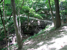
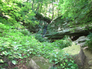
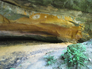
The sand cave hike is an exploration of a ravine and ledge system midway down the bluff. At one point in the ledge runoff has carved a large but shallow cave out of a striking orange red rock. The cave is always cooler than the surrounding land, which is a blessing in the summer and a bit of a challenge during the other three seasons.
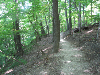
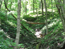
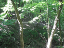
The hike is pretty and peaceful, especially during the fall when the leaves are in full color.
- Approach
-
From the Walmart in Prairie Du Chien Wisconsin, head east on Wisconsin Hwy 35 (also US-18) for 5 miles to County Rd. C, which you will intersect just after crossing the Wisconsin River.
Take a right on Cty Rd C and head west and south for 3.1 miles to Cty Rd. X.
Take a right on Cty Rd X and head west for 1.0 miles to the entrance for Wyalusing State Park.
Take a right into the park and head north 1.5 miles to the trailhead for Sand Cave, which will be a pullout parking lot on your right.
You will pass an entrance station after you enter the park where you will need to pay a fee to enter.
Coordinates for the hike: 42.9904150,-91.1163510
- Parking / Trailhead amenities
- The parking lot is a deep pulloff along the main park road. There is a fieldstone shelter and a blue water fountain adjacent to the parking lot. There are no toilets at the parking lot, but there are several just a little ways up the road. There is also a snack stand and vending machines near the campgrounds.
- Trail observations
- The trail leaves the parking pullout on the side opposite of the main road - there is a signpost at the trailhead for both the Sand Cave Trail and the Walnut Springs trail, which run together for a short ways.
The Sand Cave Trail splits to the left, then starts descending till it reaches a side branch for the Sand Cave. Visit the cave, then return to the trail and continue on to do a loop along a fairly tell ledge. The loop will bring you back to the trail, which you will then follow back to the parking lot. - Trail statistics
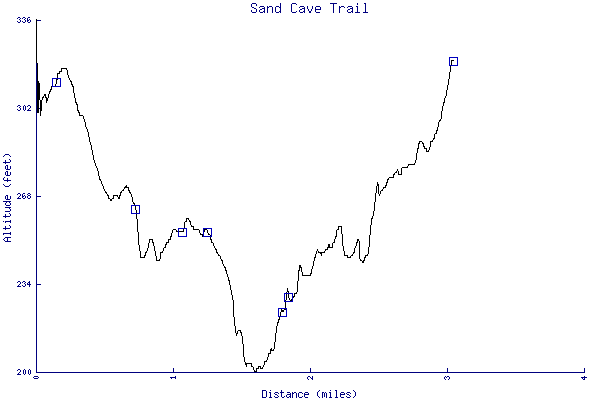
- The trail is 3.04 miles long. The sum of all the uphill climbs is 253 feet.
- Trail waypoints
0.09 mi Trailhead Trailhead 0.10 mi Parking Parking lot 0.16 mi Stay left Branch - stay left 0.74 mi Side branch to cave Take side branch down to Sand Cave, then return 1.08 mi Sand cave Turnaround point - return and take the other branch 1.25 mi Go left Branch - stay left 1.47 mi On cliff Following cliff 1.80 mi Switchbacks Climbing up a switchback 1.85 mi Waterfall Waterfall 3.04 mi End of trail End of trail


- Keywords
- Difficulty: Easy
- Feature: Cave
- Terrain : Hilly
- Trail surface: Dirt
- Type: Lollipop
- View: Enclosed
- View: Wooded
- County: Clayton
- State: Wisconsin
- Country: United States of America
- Links
- Wisconsin DNR site
- Trail map
- Resources
- Printable trail map in PDF format (13 Mb download)
- Printable trail map in PNG format (3 Mb download)
- Waypoints in CSV format
- Waypoints in KML format
- Instructions on using a trail description page
- Instructions on using a trail map printout
- Trails in the surrounding area
- Trailheads for Iowa Minnesota, and Wisconsin (6 additional trails)
- Trailheads for Illinois Iowa, Minnesota, and Wisconsin (6 additional trails)
- Trailheads for Illinois Iowa, Minnesota, and Wisconsin (1 additional trail)
Copyright © 2011 RambleFeet LLC. All rights reserved.